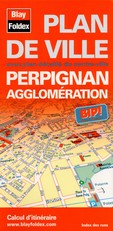
Perpignan city map|Languedoc-Roussillon|1:10,000|BLAY FOLDEX
£4.95
Stock Status: In Stock
Description
Description
Detailed street map of Perpignan and its suburbs in the southern French region of Languedoc-Roussillon. Includes a separate map of central Perpignan, shown at 1:6,400. The map comes with a 32-page booklet featuring historical and practical information on Perpignan and street indexes of Perpignan and the surrounding towns of Baho, Bompass, Cabestany, Canohès, Pia, Rivesaltes, Saint-Estève and Toulouges.
| ISBN/EAN | 978 1 85879 1326 |
|---|---|
| Scale | 1: 10,000 |
| Format | Folded Map |
| Publisher | Blay Foldex |
Reviews (0)
You must be logged in to post a review.

Reviews
There are no reviews yet.